קובץ:Ocean drainage.png
תוכן הדף אינו נתמך בשפות אחרות.
מתוך ויקימילון, מיזם רב לשוני ליצירת מילון חופשי שיתופי.

לקובץ המקורי(1,256 × 656 פיקסלים, גודל הקובץ: 75 ק"ב, סוג MIME‏: image/png)

זהו קובץ מתוך ויקישיתוף וניתן להשתמש בו גם במיזמים אחרים. תיאורו בדף תיאור הקובץ שלו מוצג למטה.

תקציר

יש ליצור מחדש את התמונה map הזו באמצעות גרפיקה וקטורית כדוגמת קובץ SVG. לפעולה זו מספר יתרונות, כפי שניתן לקרוא (באנגלית) בדף Commons:Media for cleanup. אם ברשותכם קובץ SVG, אנא העלו אותו. לאחר מכן, החליפו תבנית זו בתבנית
{{vector version available|שם הקובץ.svg}}
תיאור
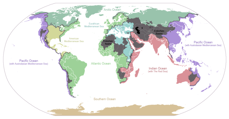
English: I made this map and hereby release it into the public domain. It shows the drainage basins for the major oceans and seas; grey areas are endorheic basins that do not drain to the ocean. Data is from the USGS Hydro1k project; information for Saskatchewan corrected by information from the Commission for Environmental Cooperation -- Citynoise
Description in large font size is used for oceans, in smaller font size is used for mediterranean seas. Only these mediterranean seas are listed which correspond to the definition of german Geographer Ernst Neef: A mediterranean sea is a sea between two Continents. Also found here: de:Mittelmeer --W like wiki (talk) 00:55, 12 March 2011 (UTC)
Français : Carte du monde des bassins versants. Les zones de couleur anthracite représentent les bassins endoréiques, qui ne sont reliés à aucun océan.
Čeština: Úmoří světových oceánů, popř. významných moří či zálivů. Legenda úmoří: fialová - Tichý oceán, růžová - Indický oceán, zelená - Atlantický oceán, azurová - Severní ledový oceán, béžová - Jižní oceán, modrá - Mexický záliv, světle modrá - Středozemní moře, šedá - oblast neústící ve světovém oceánu
תאריך יצירה ‏24 בינואר 2007‏ (תאריך העלאה מקורי)
מקור הועבר מ- en.wikipedia לוויקישיתוף.
יוצר Citynoise מוויקיפדיה האנגלית
גרסאות אחרות File:Major endorheic basins.png

רישיון

Public domain היצירה הזאת שוחררה לנחלת הכלל על־ידי היוצר שלה, Citynoise מוויקיפדיה האנגלית. זה תקף בכל העולם.
יש מדינות שבהן הדבר אינו אפשרי על פי חוק, אם כך:
Citynoise מעניק לכל אחד את הזכות להשתמש ביצירה הזאת לכל מטרה, ללא שום תנאי, אלא אם כן תנאים כאלה נדרשים לפי החוק.

יומן העלאה מקורי

תיאור הקובץ המקורי נמצא כאן. כל שמות המשתמשים הבאים מתייחסים ל-en.wikipedia.
  • 2007-05-20 17:59 Bolonium 1256×656×8 (50194 bytes) I made this map and hereby release it into the public domain. It shows the drainage basins for the major oceans and seas; grey areas are endorheic basins that do not drain to the ocean. -- [[User:Citynoise|Citynoise]] == Licensing == {{self
  • 2007-01-24 07:21 Citynoise 1256×656×8 (63359 bytes) I made this map and hereby release it into the public domain. It shows the drainage basins for the major oceans and seas; grey areas are endorheic basins that do not drain to the ocean.
  • 2007-01-24 06:09 Citynoise 1256×656×8 (57358 bytes) I made this map and hereby release it into the public domain. It shows the drainage basins for the major oceans and seas; grey areas are endorheic basins that do not drain to the ocean.
  • 2007-01-24 05:10 Citynoise 1256×656×8 (56360 bytes) I made this map and hereby release it into the public domain. It shows the drainage basins for the major oceans and seas; grey areas are endorheic basins that do not drain to the ocean.
  • 2007-01-24 04:55 Citynoise 1256×656×8 (56373 bytes) I made this map and hereby release it into the public domain. It shows the drainage basins for the major oceans and seas; grey areas are endorheic basins that do not drain to the ocean.

כיתובים

נא להוסיף משפט שמסביר מה הקובץ מייצג
Drainage basins of the world, colored by ocean outlet. Endorheic basins not draining to an ocean are colored dark gray. Continental divides are indicated by dark lines.

פריטים שמוצגים בקובץ הזה

מוצג

היסטוריית הקובץ

ניתן ללחוץ על תאריך/שעה כדי לראות את הקובץ כפי שנראה באותו זמן.

תאריך/שעהתמונה ממוזערתממדיםמשתמשהערה
נוכחית02:25, 7 באוקטובר 2015תמונה ממוזערת לגרסה מ־02:25, 7 באוקטובר 2015‪656 × 1,256‬ (75 ק"ב)AcidSnowFixed Somalia.
03:39, 12 במרץ 2011תמונה ממוזערת לגרסה מ־03:39, 12 במרץ 2011‪656 × 1,256‬ (76 ק"ב)W like wikiInsert Description. Big font size is used for oceans, smaller font size is used for mediterranean seas.
14:13, 30 ביוני 2009תמונה ממוזערת לגרסה מ־14:13, 30 ביוני 2009‪656 × 1,256‬ (40 ק"ב)U7vGuntransparentize background,improve some details.
23:45, 26 ביולי 2008תמונה ממוזערת לגרסה מ־23:45, 26 ביולי 2008‪656 × 1,256‬ (62 ק"ב)Citynoise{{Information |Description=added endorheic basins in Saskatchewan. |Source=my own work |Date=July 2008 |Author=Citynoise |Permission=all rights released |other_versions= }}
22:46, 27 בנובמבר 2007תמונה ממוזערת לגרסה מ־22:46, 27 בנובמבר 2007‪656 × 1,256‬ (49 ק"ב)File Upload Bot (Magnus Manske) {{BotMoveToCommons|en.wikipedia}} {{Information |Description={{en|I made this map and hereby release it into the public domain. It shows the drainage basins for the major oceans and seas; grey areas are en:endorheic basins that do not drain to the

אין דפים המשתמשים בקובץ זה.

שימוש גלובלי בקובץ

אתרי הוויקי השונים הבאים משתמשים בקובץ זה:

צפייה בשימושים גלובליים נוספים של קובץ זה.

מטא־נתונים