
קובץ:Europe w asia n africa.jpg

לקובץ המקורי (2,305 × 1,863 פיקסלים, גודל הקובץ: 850 ק"ב, סוג MIME: image/jpeg)
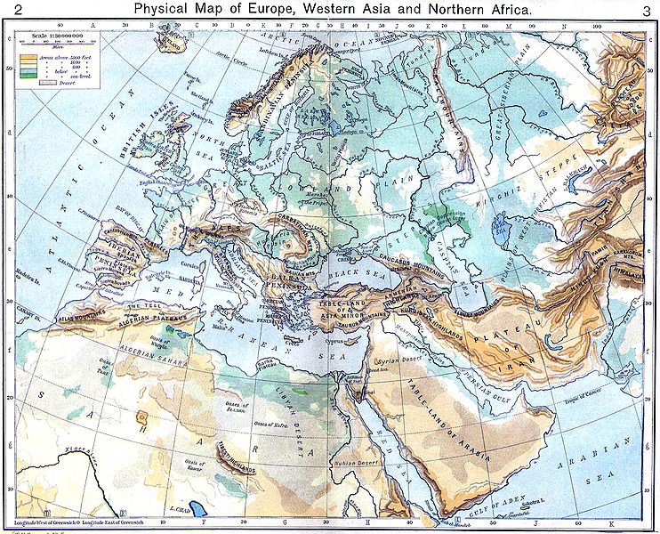
{[ew|en|Wirya}} A historical Physical Map of Europe, Western Asia and Northern Africa by William R. Shepherd, New York, Henry Holt and Company, 1926. Map from: [1], in Public Domain
![[1]](http://www.lib.utexas.edu/maps/historical/shepherd/europe_w_asia_n_africa.jpg)
|
יצירה זו נמצאת בנחלת הכלל במדינת המקור ובמדינות אחרות בהם תקופת זכויות היוצרים היא משך חיי היוצר ו-70 שנה (או פחות) מפטירתו.
| |
| הקובץ הזה זוהה כקובץ חופשי מכל מגבלה ידועה תחת חוק זכויות היוצרים, כולל כל הזכויות הקשורות והסמוכות. | |
היסטוריית הקובץ
ניתן ללחוץ על תאריך/שעה כדי לראות את הקובץ כפי שנראה באותו זמן.
| תאריך/שעה | תמונה ממוזערת | ממדים | משתמש | הערה | |
|---|---|---|---|---|---|
| נוכחית | 16:12, 6 בדצמבר 2009 | | 1,863 × 2,305 (850 ק"ב) | Alex:D | colors |
| 17:25, 6 בספטמבר 2009 |  | 1,863 × 2,305 (644 ק"ב) | Qorilla | colors | |
| 17:53, 3 בדצמבר 2006 |  | 1,863 × 2,305 (641 ק"ב) | Electionworld | {[ew|en|Wirya}} A historical Physical Map of Europe, Western Asia and Northern Africa by William R. Shepherd, New York, Henry Holt and Company, 1926. Map from: [http://www.lib.utexas.edu/maps/historical/shepherd/europe_w_asia_n_africa.jpg], in Public Doma |
שימוש בקובץ
הדפים הבאים משתמשים בקובץ הזה:
שימוש גלובלי בקובץ
אתרי הוויקי השונים הבאים משתמשים בקובץ זה:
- שימוש באתר ba.wikipedia.org
- שימוש באתר en.wikipedia.org
- שימוש באתר fr.wikipedia.org
- שימוש באתר he.wikipedia.org
- מטאורולוגיה
- מדבר
- שפך נהר
- נחל
- יבשת
- מדעי האטמוספירה
- מצר ים
- זרם ים
- נהר
- אוקיינוגרפיה
- מפרץ
- קלימטולוגיה
- אוקיינוס
- ים
- אי
- חצי אי
- גאוגרפיה פיזית - מונחים
- טקטוניקת הלוחות
- גובה פני הים
- ארכיפלג
- אגם
- קרקע
- נווה מדבר
- מצר יבשה
- דלתה
- תבנית:גאוגרפיה פיזית
- אטול
- גאומורפולוגיה
- חולית (גאוגרפיה)
- סוואנה
- אוקיינוגרפיה פיזיקלית
- הידרולוגיה
- מעיין
- ערבה (גאוגרפיה)
- הידרוגרפיה
- פלאוקלימטולוגיה
- גאוגרפיה פיזית
- יובל (נהר)
- אבן חוף
- בליה חופית
- בליה ביולוגית
- חולות נודדים
- אוקיינוגרפיה כימית
- מוצא (גאוגרפיה)
- מפרצון
- שימוש באתר it.wikipedia.org
צפייה בשימושים גלובליים נוספים של קובץ זה.